观云识天:这6种气象云帮你预知天气(组图) Here are 6 clouds you can actually use to tell the weather
中国日报网 2018-07-05 08:57

&pic=http://img2.chinadaily.com.cn/images/201807/05/5b3d6d04a31033495a589012.jpeg&url=https://language.chinadaily.com.cn/a/201807/05/WS5b3d6d04a3103349141e0c77.html)
&pics=http://img2.chinadaily.com.cn/images/201807/05/5b3d6d04a31033495a589012.jpeg&url=https://language.chinadaily.com.cn/a/201807/05/WS5b3d6d04a3103349141e0c77.html)


虽然现在电脑预报天气的技术越来越先进,但是天有不测风云,天气预报总有不准的时候。其实,早在古代,人们就已经会“看云识天气”,学会看云的形状,你就能预知几小时后天气的变化。今天我们就来认识几种常见的气象云。
1. Cumulus['kjumjələs] 积云
Clouds form when air cools to the dew point, the temperature at which the air can no longer hold all its water vapour. At this temperature, water vapour condenses to form droplets of liquid water, which we observe as a cloud.
空气冷却到露点的时候就会形成云,在这个温度,空气已经无法承载所有的水汽。在露点温度下,水汽凝结成小滴的液态水,也就是我们所看到的云。
For this process to happen, we require air to be forced to rise in the atmosphere, or for moist air to come into contact with a cold surface.
要形成云,需要空气被迫在大气中上升,或者湿润的空气和冰冷的表面接触。
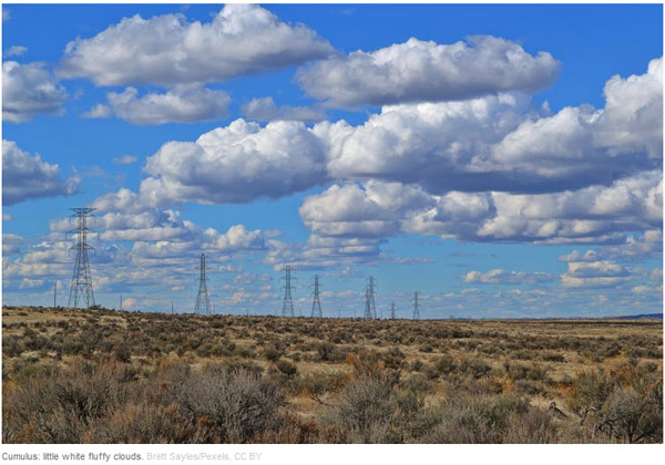
On a sunny day, the sun's radiation heats the land, which in turn heats the air just above it. This warmed air rises by convection and forms Cumulus. These "fair weather" clouds look like cotton wool.
在晴天时,阳光让大地升温,从而让大地上方的空气也升温。这些温暖的空气通过对流上升,形成积云。这些“好天气”的云看上去就像棉絮一般。
If you look at a sky filled with cumulus, you may notice they have flat bases, which all lie at the same level. At this height, air from ground level has cooled to the dew point. Cumulus clouds do not generally rain – you're in for fine weather.
如果你看见天空布满了积云,你可能会注意到它们的底部都是平的,而且都位于同一水平线上。在这个高度,来自地面的空气已经冷却到露点。积云一般不会化成雨,它预示着好天气。
2. Cumulonimbus[,kjuməlo'nɪmbəs] 积雨云
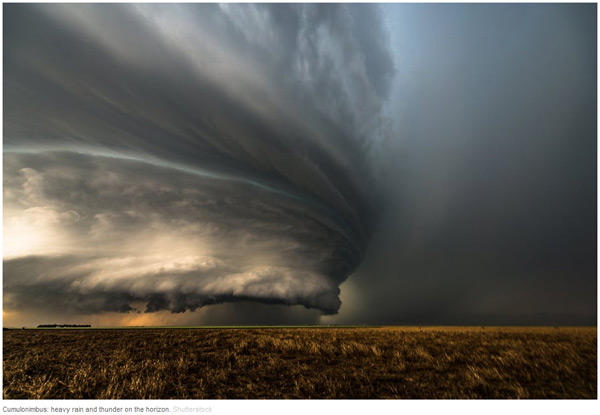
While small Cumulus do not rain, if you notice Cumulus getting larger and extending higher into the atmosphere, it's a sign that intense rain is on the way. This is common in the summer, with morning Cumulus developing into deep Cumulonimbus (thunderstorm) clouds in the afternoon.
虽然小的积云不下雨,但如果你注意到积云变大并向大气高处延伸,这预示着强降雨即将到来。这在夏季很常见,早晨的积云到了下午可能就变成了厚厚的积雨云(雷雨)。
Near the ground, Cumulonimbus are well defined, but higher up they start to look wispy at the edges. This transition indicates that the cloud is no longer made of water droplets, but ice crystals. When gusts of wind blow water droplets outside the cloud, they rapidly evaporate in the drier environment, giving water clouds a very sharp edge.
靠近地表时,积雨云的边界都比较分明,但到了大气高处,它们的边缘开始出现条缕状。这种转变预示着云朵不再由水滴组成,而是由冰晶构成。当一阵阵的风吹动云朵外层的水滴,水滴在干旱环境下就会迅速蒸发,让云朵边缘看上去很尖锐。
On the other hand, ice crystals carried outside the cloud do not quickly evaporate, giving a wispy appearance.
与此同时,云朵外层的冰晶却没有蒸发得那么快,于是就出现了条缕状的云朵外观。
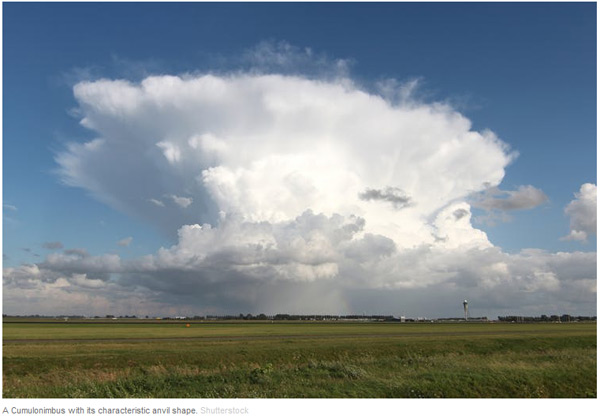
Cumulonimbus are often flat-topped. Within the Cumulonimbus, warm air rises by convection. In doing so, it gradually cools until it is the same temperature as the surrounding atmosphere.
积雨云通常在顶部是平的。在积雨云内部,暖空气通过对流上升,在上升过程中逐渐冷却,直到和周围大气温度一致。
At this level, the air is no longer buoyant so cannot rise further. Instead it spreads out, forming a characteristic anvil shape.
上升到这个高度后,空气不再活跃,也不再上升,而是扩散开来,形成特有的砧形。
3. Cirrus['sɪrəs] 卷云
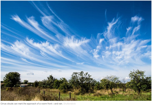
Cirrus form very high in the atmosphere. They are wispy, being composed entirely of ice crystals falling through the atmosphere. If Cirrus are carried horizontally by winds moving at different speeds, they take a characteristic hooked shape.
卷云在大气高处形成。它们呈条缕状,完全由大气中落下的冰晶组成。如果卷云被运动速度不同的风水平吹动,它们会呈现特有的钩形。
Only at very high altitudes or latitudes do Cirrus produce rain at ground level.
只有在非常高的高度或纬度,卷云才会化成雨降到地面。
But if you notice that Cirrus begins to cover more of the sky, and gets lower and thicker, this is a good indication that a warm front is approaching. In a warm front, a warm and a cold air mass meet. The lighter warm air is forced to rise over the cold air mass, leading to cloud formation.
但如果你注意到卷云开始覆盖天空的大部分,位置变低,云块变厚,这预示着暖锋正在靠近。暖锋就是暖空气团和冷空气团相遇。重量更轻的暖空气团被迫升到冷空气团上方,导致卷云的形成。
The lowering clouds indicate that the front is drawing near, giving a period of rain in the next 12 hours.
云层变低预示着暖锋临近,在未来12个小时将会下雨。
4. Stratus['stretəs] 层云
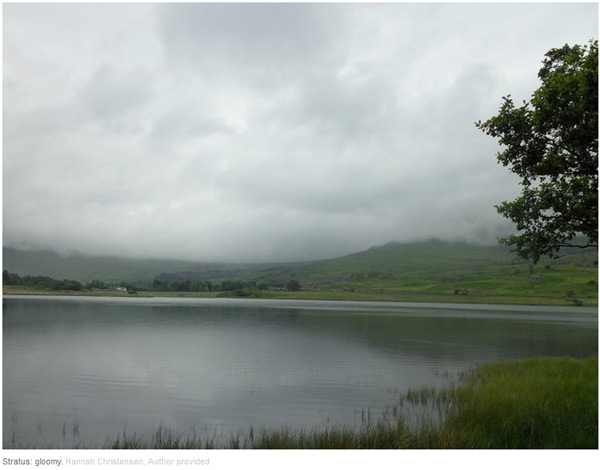
Stratus is a low continuous cloud sheet covering the sky. Stratus forms by gently rising air, or by a mild wind bringing moist air over a cold land or sea surface. Stratus cloud is thin, so while conditions may feel gloomy, rain is unlikely, and at most will be a light drizzle.
层云是低低地覆盖天空的连续云层。层云由缓慢上升的空气形成,或是轻风将湿润空气吹过冰冷的地面或海平面形成。层云比较薄,所以尽管天气阴阴的,但却不太可能下雨,最多是毛毛雨。
Stratus is identical to fog, so if you've ever been walking in the mountains on a foggy day, you've been walking in the clouds.
层云和雾差不多,所以如果你曾在雾天上山,那就是云中漫步。
5. Lenticular[lɛn'tɪkjəlɚ] 荚状云
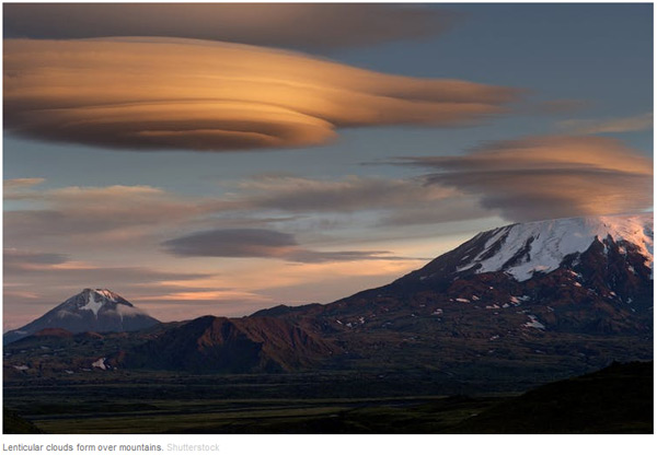
Our final two cloud types will not help you predict the coming weather, but they do give a glimpse of the extraordinarily complicated motions of the atmosphere.
我们最后要说的两种云不能帮你预告天气,但是可以瞥见大气异常复杂的变化。
Smooth, lens-shaped Lenticular clouds form as air is blown up and over a mountain range.
平滑的透镜形状的荚状云是空气膨胀时在山脉上方形成。
Once past the mountain, the air sinks back to its previous level. As it sinks, it warms and the cloud evaporates. But it can overshoot, in which case the air mass bobs back up allowing another Lenticular cloud to form.
一旦经过山脉,空气就缩回到原先的水平。空气收缩时会升温,云朵会蒸发。但如果收缩过了头,空气团就会回弹,形成另一朵荚状云。
This can lead to a string of clouds, extending some way beyond the mountain range. The interaction of wind with mountains and other surface features is one of the many details that have to be represented in computer simulators to get accurate predictions of the weather.
由此产生的一连串荚状云会延伸到山脉的另一边。风和山及其他地貌的相互作用是电脑模拟器需要考虑的众多细节之一,否则无法准确预测天气。
6. Kelvin-Helmholtz['kɛlvɪn]['helmhəults] 开尔文-亥姆霍兹浪状云
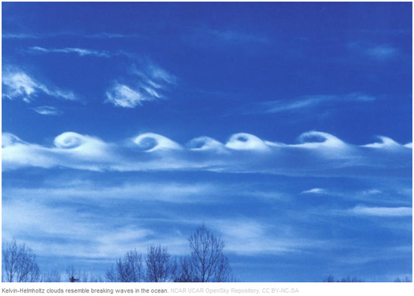
The Kelvin-Helmholtz cloud resembles a breaking ocean wave.
开尔文-亥姆霍兹浪状云就像被打碎的海浪。
When air masses at different heights move horizontally with different speeds, the situation becomes unstable. The boundary between the air masses begins to ripple, eventually forming larger waves.
当不同高度的空气团以不同速度横向移动时,情况就会变得不稳定起来。空气团的边界开始起波纹,最后形成更大波浪。
Kelvin-Helmholtz clouds are rare, because we can only see this process taking place in the atmosphere if the lower air mass contains a cloud.
开尔文-亥姆霍兹浪状云很罕见,因为这一过程只有在低处空气团中有云时才会发生。
The cloud can then trace out the breaking waves, revealing the intricacy of the otherwise invisible motions above our heads.
从这种云展现的碎浪形状可以窥见我们头顶上原本看不见的微妙变化。
英文来源:The Conversation
翻译&编辑:丹妮


 英语点津微信
 双语小程序
双语小程序