中国网站品牌栏目(频道)
CHRISTOPHER CRUISE: This is SCIENCE IN THE NEWS in VOA Special English. I'm Christopher Cruise.
SHIRLEY GRIFFITH: And I'm Shirley Griffith. Today we tell about the science of severe ocean storms. Severe ocean storms that develop over the Indian Ocean are called cyclones. Storms that form over the northwestern Pacific Ocean are typhoons. And storms that form over the eastern Pacific Ocean and the Atlantic Ocean are hurricanes.
(MUSIC)
CHRISTOPHER CRUISE: A storm with a misleadingly pleasant name recently brought death and destruction to parts of North America.
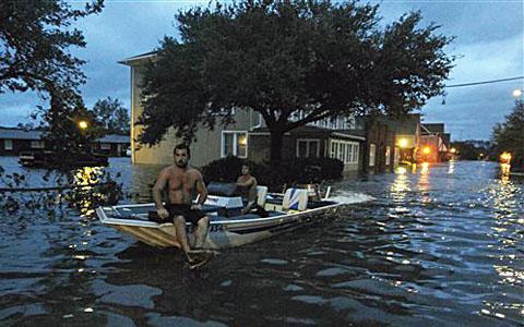
Wide, slow-moving Hurricane Irene began to organize over the Lesser Antilles Islands in the Caribbean Sea. Later Irene gained strength. The storm stretched about 1770 kilometers along the eastern United States. Its destructive winds and heavy rain reached far inland. Even after it weakened, Irene carried disaster as far north as Quebec and Nova Scotia in Canada.
A storm survivor in New England made a prediction as he repaired storm damage to his property. He said he believes fewer people will name their children "Irene" after this storm.
Something similar happened after Hurricane Katrina struck the south central United States in 2005. America's Social Security Administration says far fewer parents named their newborn daughters Katrina in the years immediately after the storm.
SHIRLEY GRIFFITH: People have called some natural events by human names for centuries. For example, the name "Thor" was given to the mythical Norse god of thunder, the loud sound that follows lightning in the sky.
An Australian scientist began calling storms by women's names before the end of the 19th century. During World War Two, scientists called storms by the names of their wives or girlfriends.
American weather experts started to use women's names for storms in 1953. In 1979, they began to use men's names, too.
CHRISTOPHER CRUISE: Scientists decide on lists of names years in advance. They decide on them at meetings of the World Meteorological Organization. The National Hurricane Center in Miami, Florida has one list for each of six years for Atlantic Ocean storms. The experts there name storms when they reach wind speeds of 62 kilometers an hour. That is true even if they never grow stronger.
The first name used in a storm season begins with the letter A. The second begins with B and so on. The letters Q, V, X, Y and Z are never used. And the same list of names is not used again for at least six years. And different lists are used for different parts of the world. A name is retired when the storm with this name has been very destructive.
In 2005, Greek letters had to be used for the first time to name storms in the Atlantic. That was the plan -- to call storms Alpha, Beta and so on -- if there were ever more than 21 named storms in a season. As it happened, there were 28.
SHIRLEY GRIFFITH: The 2005 Atlantic hurricane season was the first on record to have 15 hurricanes. Four reached Category Five strength, also a first. And the National Oceanic and Atmospheric Administration says it was the first season when four major hurricanes hit the United States. The most destructive was Katrina. It was blamed for more than 1800 deaths along the Gulf of Mexico.
(MUSIC)
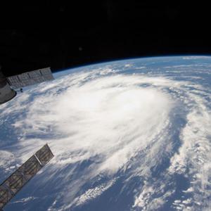
CHRISTOPHER CRUISE: Ocean storms develop when the air temperature in one area is different from the temperature nearby. Warmer air rises, while cooler air falls. These movements create a difference in atmospheric pressure.
If the pressure changes over a large area, winds start to blow in a huge circle. High-pressure air is pulled toward a low-pressure center. Thick clouds form and heavy rains fall as the storm gains speed and moves over the ocean. Storms can get stronger as they move over warm ocean waters.
The strongest, fastest winds of a hurricane blow in the area known as the eyewall. It surrounds the center, or eye, of the storm. The eye itself is calm by comparison.
SHIRLEY GRIFFITH: Wind speeds in the most severe ocean storms can reach more than 250 kilometers an hour. Up to 50 centimeters of rain can fall. Some storms have produced more than 150 centimeters of rain.
These storms also cause high waves and ocean surges. A surge is a continuous movement of water that may reach as high as six meters or more. The water strikes low coastal areas. Surges are commonly responsible for about 90 percent of all deaths from ocean storms.
(MUSIC)
CHRISTOPHER CRUISE: The National Hurricane Center in Miami keeps close watch on severe storms. It works with government officials and with radio and television stations to keep people informed. Experts believe this early warning system has helped reduce deaths from ocean storms in recent years.
But sometimes people cannot or will not flee the path of a storm. That is what happened in many places in Louisiana when Hurricane Katrina struck.
Studies have shown that some people do not leave a storm-threatened area because they have no transportation or money for transportation. Another reason is that they fear that their property will be damaged by other people, if not by the storm.
Still another is that people do not want to leave their pets or farm animals. Today, more plans exist for animal care during severe storms than in years before.
SHIRLEY GRIFFITH: Weather experts use computer programs to create models that show where a storm might go. The programs combine information such as temperatures, wind speed, atmospheric pressure and the amount of water in the atmosphere.
Scientists collect the information with satellites, weather balloons and devices floating in the oceans. They also receive information from ships and passenger airplanes and other flights. Government scientists use specially-equipped planes to fly into and around storms. The crews drop instruments tied to parachutes. The instruments collect information about temperature, pressure and wind speed.
CHRISTOPHER CRUISE: Scientists use the Saffir-Simpson Hurricane Scale to measure the intensity of storms based on wind speed. The scale provides an idea of the amount of coastal flooding and property damage that might be expected. The scale is divided into five groups or categories. The mildest hurricane is a category one. It has winds of about 120 to 150 kilometers an hour. This storm can damage trees and lightweight structures. It can also cause flooding.
Wind speeds in a category two hurricane can reach close to 180 kilometers an hour. These storms are often powerful enough to break windows or blow the tops off houses.
SHIRLEY GRIFFITH: Winds between about 180 and 250 kilometers an hour represent categories three and four. A more powerful storm is a category five hurricane. Researchers say forces other than wind speed help cause extensive destruction. And the lower the air pressure, the stronger the storm. Hurricane Irene's most damaging power, however, came from water. In some areas of Vermont, for example, storm surges caused record flooding.
In all, Irene was blamed for more than 40 deaths in the United States.
(MUSIC)
CHRISTOPHER CRUISE: Some scientists believe climate change affects major storms. They say the warming of Earth's atmosphere is already making the storms worse. Other scientists have published studies that disagree.
Last year, a special committee of the World Meteorological Organization reported on severe storms. The committee's work appeared in the journal "Nature Geoscience." Ten scientists wrote the report. They represented both sides of the debate about global warming. The scientists reached no clear answer about whether rising temperatures on Earth had already intensified storms. Still, they made some predictions.
SHIRLEY GRIFFITH: The committee said global warming might cause more powerful ocean storms in the future. It said the overall strength of storms measured by wind speed might increase two to 11 percent by the year 2100. And there might be an increase in the number of the most severe storms. But there might be fewer weak and moderate storms.
The current Atlantic Ocean hurricane season began in June. A tropical storm killed 11 people in Mexico. But experts say none of the first eight named storms of the season gained hurricane strength. That set a record. Then, in late August, came Hurricane Irene.
(MUSIC)
CHRISTOPHER CRUISE: This SCIENCE IN THE NEWS was written by Jerilyn Watson. June Simms was our producer. I'm Christopher Cruise.
SHIRLEY GRIFFITH: And I'm Shirley Griffith. Listen again next week for more news about science in Special English on the Voice of America.
Hurricane Irene hits northeastern United States
Lovely Day Today... 有150年历史的气象预报
Climate patterns can predict El Nino's arrival
(来源:VOA 编辑:张若琼)