 |
|
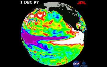
The World Meteorological Organisation (WMO) said its modelling suggested a "fairly large potential for an El Nino, most likely by the end of the second quarter of 2014" Photo: NASA |
|
The UN weather agency warned on Tuesday there was a good chance of an "El Nino" climate phenomenon in the Pacific Ocean this year, bringing droughts and heavy rainfall to the rest of the world. The World Meteorological Organisation (WMO) said its modelling suggested a "fairly large potential for an El Nino, most likely by the end of the second quarter of 2014". "If an El Nino event develops ... it will influence temperatures and precipitation and contribute to droughts or heavy rainfall in different regions of the world," Michel Jarraud, WMO chief, said in a statement. The El Nino phenomenon occurs every two to seven years, when the prevailing trade winds that circulate surface water in the tropical Pacific start to weaken. WMO pointed out Tuesday that since February, trade winds had weakened and there had been a significant warming of the waters below the surface in the central Pacific. "While there is no guarantee this situation will lead to an El Nino event, the longer the trade winds remain weakened, and subsurface temperatures stay significantly warmer than average, the higher the likelihood," it said. Two thirds of climate models predicted that the phenomenon would begin sometime between June and August, with a few suggesting it could start as early as May, and the remainder predicting no El Nino this year, it said. The last El Nino occurred between June 2009 and May 2010. It is often followed by a return swing of the pendulum with La Nina, which is characterised by unusually cool ocean surface temperatures in the central and eastern tropical Pacific. Scientists, who closely monitor the two climate patterns, say that while they are not caused by climate change, rising ocean temperatures caused by global warming may affect their intensity and frequency. "El Nino has an important warming effect on global average temperatures," Jarraud cautioned, stressing that combined with human-induced warming from greenhouse gases such events had "the potential to cause a dramatic rise in global mean temperature". |
据《每日电讯报》4月15日报道,联合国气象机构周二警告说,今年太平洋很有可能出现厄尔尼诺现象,给世界其他地区带来干旱和暴雨天气。 世界气象组织(WMO )表示,该组织所建模型显示2014年第二季度末之前极有可能出现厄尔尼诺现象。 “厄尔尼诺现象一旦出现……它会影响气温和降水,并会促成世界不同地区的干旱或大雨,”世界气象组织秘书长米歇尔·雅罗在一份声明中说。 每两到七年,当环绕太平洋热带水域的盛行信风减弱时,就会出现厄尔尼诺现象。 本周二世界气象组织指出,2月份以来,信风减弱了,而且太平洋中部水域表面下水温变暖显著。 声明称,“虽然也不能保证这种情况会导致厄尔尼诺现象,但是信风减弱时间越长,表面下水温比常年变暖越显著,出现厄尔尼诺现象的可能性就越高”。 三分之二的气候模型预测这种现象将出现在今年六月至八月间,还有几个显示它可能在五月开始,而剩下的则预测没有厄尔尼诺现象,该声明说。 上一次出现厄尔尼诺现象是在2009年6月至2010年5月之间。 紧跟在厄尔尼诺现象之后的往往是拉尼娜现象的回转,其特点是中部和东部热带太平洋表面温度比正常温度低。 密切监察这两个气候模式的科学家说,虽然它们不是由气候变化所致,但全球变暖导致的海洋温度的上升可能会影响其强度和频率。 雅罗警告说,“厄尔尼诺对全球平均温度变暖有重要影响”,他还强调说,加之温室气体排放引起的人为气候变暖因素,这样的现象“可能造成全球平均气温急剧上升” 。 (译者 feilongmengjian 编辑 齐磊) 扫一扫,关注微博微信
  |